Dajiang UAV no-fly zone query_Dajiang drone no-fly zone
UAVs have been known by more and more people, aerial photography, express delivery, power line inspection, disaster relief, and drones can be used in almost every industry. Its figure is now everywhere. The well-known consulting firm Gartner predicts that the production and sales volume of drones will increase by 39% in 2017 to 3 million units, and the global market revenue is expected to reach US$6 billion. This emerging industry has encountered many problems. The first thing that bears the brunt is the huge security risks brought by "Black Flying." In recent years, drones have frequently broken into the "clean space" of airports around the country, causing flights to be delayed many times, and airports in Shenzhen, Hangzhou, and Xining have been "invited". Previously, there was a video of a drone taking a close-up shot of a passenger airliner on the network. However, the current laws and regulations on drones are still unclear, and the supervision of drones is in a gray area. UAVs often interfere with aviation safety. How do you manage such a dangerous thing?
In this regard, the industry giant DJI innovation has taken action. On the evening of March 2nd, DJI Dajiang Innovation released a polygonal no-fly zone strategy, and the no-fly zone setting was more flexible. The aircraft will not be able to take off in the no-fly zone; it will automatically decelerate and hover when approaching the boundary of the no-fly zone from the outside. The update of this strategy will take effect first at the mainland China airport and will gradually be promoted globally.
Close to the no-fly zone drone automatically decelerate and hoverDJI Innovation announced on the evening of March 2 that in order to ensure the safety of public airspace and protect the flight experience of users, DJI has set up an airport no-fly zone and a flight-limited zone for its drone products. A circular area with a radius of 4.5 km at the ends of each runway of the airport, a flat ellipse consisting of two circles and edge lines is the no-fly zone. The aircraft cannot take off in the no-fly zone; when it approaches the boundary of the no-fly zone from the outside, it will automatically decelerate and hover. If the no-fly zone enters the no-fly zone without GPS signal, the drone will automatically land after receiving the GPS signal.
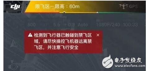
In addition to the no-fly zone, there are also 30-meter, 60-meter and 120-meter flight-limited zones. Take the 60-meter flight-defending area as an example. It is a trapezoidal range with 15 km of both ends of the runway and a diffusion slope of 15%. It is not intersecting with the 30-meter fly-limited zone and the no-fly zone. The height limit is 60 meters. When the aircraft approaches the boundary of the flight zone from the outside, the application will pop up a warning indicating the risk of flight. If the current altitude is greater than the limit height, the aircraft will automatically decelerate, hover, and must descend below the limit fly height to enter. Dajiang's product lines will gradually apply to the updated polygon no-fly zone strategy.
In fact, this is not the first time that Dajiang has introduced the no-flyer no-fly zone. "According to ICAO and national air traffic control regulations for air traffic control and the regulation of drones, drones must fly in the prescribed airspace." Dajiang official website shows that it increases special regional flight restrictions for drones. Function, airports in several countries on six continents and some special areas are included in the no-fly/limited zone.
What is the difference between the new polygon no-fly zone strategy released by Dajiang? "It turned out to be a one-size-fit circular no-fly zone. Now it is a polygonal no-fly zone with more flexible space." Shao Jian, vice president of Dali Innovation, said in an interview with the Nanfang Daily reporter that Dajiang began to consider this technical solution very early. On the one hand, it can take into account aviation safety, on the other hand, it can also guarantee the flight airspace to a greater extent.
Before the Dajiang UAV took a high-altitude shooting of a passenger airliner, was it the trigger for the release of the new regulations in Dajiang? In this regard, Shao Jianqi said that Dajiang’s development of technology is not a one-step process. The recent frequent security incidents have indeed accelerated the process of formulating new regulations. “We could have been in step with the corresponding government departments, but now we are ahead of the enterprise. The social responsibility, the problem is placed there, can not wait until the decision mechanism is out and then resolved."
"Daijiang's positive attitude towards social public opinion is worthy of recognition. UAV safety supervision has become an industry problem, and many functional departments are also concerned." Ke Yubao, executive secretary of the China Aircraft Owners and Pilots Association (AOPA), revealed that the civil aviation department Several meetings have been held on the electronic fence of the drone and the flight control code. The release of these technologies and how to publish them at the conference are all hot topics.
After the release of the new polygonal no-fly zone strategy, Dajiang still has no interest in the safety management of drones. Dajiang Innovation revealed that Dajiang will fully use the ADS-B receiver and other manned aircraft early warning systems in the future. The civil aircraft information received by the drone will prompt the user after data protection processing, and force the drone to descend when necessary. Or landing to avoid. Shao Jianqi told the Nanfang Daily reporter that the core technology of Dajiang is mature and is undergoing corresponding tests. “We will apply technology to future products as soon as possible, and we will propose better solutions.â€
Shao Jianqian believes that how to operate the integrated airspace in the future is also a category that the government and UAV companies need to consider. “The airspace needs to be rationalized and more refined. The fundamental purpose is to let the drone and manned aircraft meet. To ensure safety, this requires us to explore more."
“The railway has a railway system, the highway has a highway system, and the drone also needs a self-contained management system.†Shao Jianbang suggested that the drone enterprises should establish their own safety standards, and the government needs to A lot of publicity and education, at the same time establish the corresponding drone operation management service system.
However, for the UAV legislation, Ke Yubao holds a relatively open attitude. "Industry needs to develop, 'blocking' is not a solution, and both grooming and propaganda go hand in hand." He said that most enterprises today only manage production and sales, but they do not undertake the obligation of flight safety propaganda, and the level of enterprises is uneven. It is necessary to introduce some mandatory policies at the government level.
"The relevant departments are not afraid of flying drones. The key is to fear that the drones will fly." Ke Yubao said that it is unrealistic for all "flying hands" to declare the flight plan separately. It is difficult for the public to declare the plan, and it is impossible to start. The management department is unable to accept a large number of flight plan declarations. "Management is to orderly and orderly to develop better." Ke Yubao believes that the aviation department can't ignore it, and it can't be "dead". "It is very important to consider the problem from the perspective of both interests. Managers have to consider users, and management needs to find a balance between the two sides."
Dajiang UAV safe flying principleSelf safety
Carefully check the appearance of the propeller and body
Ensure that the battery, remote control, and mobile devices are fully charged
Take off after getting an outstanding GPS signal
Public safety
Stay away from the crowd and build
Keep away from wires, towers and signal stations
Flying in line of sight
Introduction to the no-flying area of ​​DajiangRecently, in order to ensure the safety of public airspace and give users a better flight experience, Dajiang released a new polygonal no-fly zone strategy. Dajiang has set up an airport no-fly zone and a flight-limited zone for its drone products. It is a circular area with a radius of 4.5 km at both ends of each runway of the airport. It consists of two round and edge lines. The ellipse is a no-fly zone. This update will take effect first at the China mainland airport and will be gradually promoted globally.
The aircraft cannot take off in the no-fly zone; when it approaches the boundary of the no-fly zone from the outside, it will automatically decelerate and hover. If the no-fly zone enters the no-fly zone without GPS signal, the drone will automatically land after receiving the GPS signal.
In addition to the no-fly zone, there are also 30-meter, 60-meter and 120-meter flight zones, as follows:
The 30-meter limit flight zone is a circle with a center point at both ends of the runway and a radius of 7 km. The flat ellipse area composed of two circles and the non-intersection with the no-fly zone is a flight-limited zone with a limit height of 30 m.
The 60-meter flight-defining zone is a trapezoidal range with a 15 km extension at both ends of the runway and a diffusion slope of 15%. It is not intersecting with the 30-meter flight-limit zone and the no-fly zone. The height limit is 60 m.
The 120-meter flight-defining zone is a circle with a radius of 10 km from the midpoint of the runway. The circular range is non-intersecting with the no-fly zone, the 30-meter flight zone and the 60-meter flight zone. The height limit is 120 m.
When the aircraft approaches the boundary of the flight zone from the outside, the application will pop up a warning indicating the risk of flight. If the current altitude is greater than the limit height, the aircraft will automatically decelerate and hover, and must descend below the limit fly height to enter; if it is below the limit fly height, the altitude will be limited after flying into the flight limit zone; if there is no GPS signal In the state, the aircraft enters the flight-limited zone, and the aircraft will automatically drop to the flight-limit height after obtaining the GPS signal.
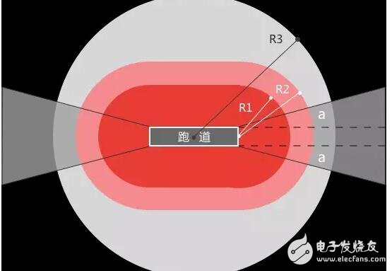
A circular area with a radius of 4.5 km at the ends of each runway of the airport, a flat ellipse consisting of two circles and edge lines is the no-fly zone. “It turned out to be a one-size-fit circular no-fly zone. Now it is a polygonal no-fly zone with more flexible space.†Shao Jian, vice president of Dali Innovation, said that Dajiang has long considered this technical solution and can take into account aviation. Safety, on the other hand, can guarantee the flight airspace to a greater extent.
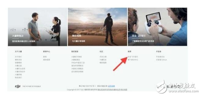
Method for querying the no-fly zone of the UAV in XinjiangInquiring method of Dajiang official website of the no-fly zone: Log in to DJI Innovation Website, pull to the bottom of the website, find the "Safe Flight Guide" under Education, click to enter [Flight Area Restriction Map] and then select [Asia], [Mainland China], Enter your area in the map [Enter Keywords] to query the flight information!
Printer Adapter means the charger of printer; the most printers used in the market are HP, EPSON, CANON and BROTHER brands, yidashun produces ac adapter for all these brands of printers. The output voltage of these printer ac adapters are normally 12V, 16V, 22V, 24V, 30V, 32V and so on, the common dc plugs are 3 hole (Flat) and 3 pin (Round).
The popular hp printer adapters are double output 32V 1.1A/ 16V 1.6A, 16V 625mA / 32V 940mA, 12V 250mA /32V 1094mA, and single output 30V 333mA, 32V 2000mA, 32V 2500mA, 22V 455mA and 32V 625mA, the dc plug of all these models are 3 hole (Flat). The popular EPSON printer charger is 24V 2A output with 3 pin (round) dc plug.


Printer Adapter,Bluetooth Printer Adapter,Wireless Printer Adapter,Wifi Printer Adapter
Shenzhen Yidashun Technology Co., Ltd. , https://www.ydsadapter.com