Talking about remote sensing technology of drone
"Remote Sensing", as its name implies, is "distant perception." Based on modern optical technology, infrared technology, radar technology, laser technology, holography technology, electronic computer technology, electronics and information theory, and other new technical sciences and earth science theory, a new and comprehensive science and technology.
The characteristics of remote sensing technology are that they do not directly contact the object of research. At high altitude or at a long distance, electromagnetic wave information that is radiated or reflected by an object is processed and processed into an image that can be recognized or recorded by an electronic computer using an electronic computer or other information processing technology. The tape, interpreted by the staff, reveals the nature, shape and dynamics of the object being measured. According to the different working wavelengths of the sensors, they can be divided into microwave remote sensing, infrared remote sensing and visible light remote sensing; they are divided into space remote sensing and aerial remote sensing according to different vehicles.
From the definition of photogrammetry and remote sensing, photogrammetry can be considered as the application of remote sensing technology in measurement work. However, today's UAV remote sensing technology has a wider range of applications.
Unmanned Aerial Vehicle Remote Sensing, which utilizes advanced unmanned aerial vehicle technology, remote sensing sensor technology, telemetry remote control technology, communication technology, GPS differential positioning technology and remote sensing application technology, can realize automation, intelligence and specialization. Quickly acquire spatial remote sensing information such as land resources, natural environment, and earthquake-stricken areas, and complete application techniques for remote sensing data processing, modeling, and application analysis. The UAV remote sensing system has become one of the main airborne remote sensing technologies in the future due to its advantages of mobility, speed and economy.
The components of the UAV remote sensing system usually include: flight platform, meteor navigation and control system, ground monitoring system, mission equipment, data transmission system, launch and recovery system, field support equipment and other ancillary equipment.
As an effective supplement to aviation and aerospace remote sensing, UAV remote sensing technology has unique advantages unmatched by other remote sensing technologies. Its main performances are as follows:
1, fast response.
The UAV system has convenient transportation, short preparation time and simple operation, and can quickly reach the monitoring area. The on-board high-precision remote sensing load can quickly obtain remote sensing monitoring results within 1-2 hours.
2. The image resolution is high.
The spatial resolution of the images obtained by remote sensing of drones reaches the decimeter level and is suitable for the needs of remote sensing applications of 1:500 or more. The high-precision digital imaging equipment on the drone is also capable of large-area coverage, vertical or tilt imaging.
3. Strong autonomy.
The drone can fly and shoot autonomously according to the scheduled flight route, and the route control precision is high. The flight height can be from 50m to 4000m, the altitude control accuracy is generally better than 10m, and the speed range is from 70km/h to 160km/h. Both can fly smoothly and adapt to different remote sensing tasks.
4, the operation is simple.
Flight operation automation, high degree of intelligence, simple operation, fault automatic diagnosis and display function, easy to master and training; once the remote control fails or other faults, it can automatically return to the takeoff point and hover. If the fault is removed, continue to fly according to ground personnel control, otherwise it will automatically open the umbrella for recycling.
As an important means of spatial data acquisition, UAV remote sensing has the advantages of long battery life, real-time image transmission, high-risk area detection, low cost and flexibility, and is widely used in many fields.
1. Application of remote sensing of UAVs in meteorological monitoring.
Unmanned meteorological aircraft can be loaded with remote sensing equipment to measure the temperature, humidity, pressure and other meteorological parameters by remote sensing, which can solve the long-term, large-area, continuous monitoring of weather changes in the air, and can obtain high-precision measurement results.
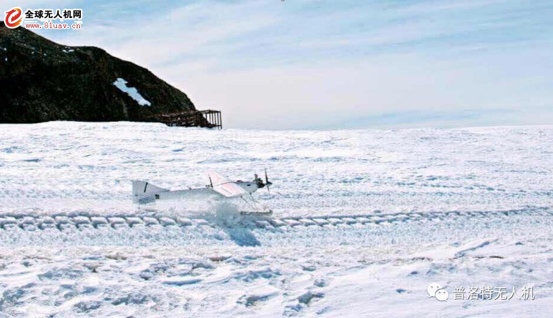
(Plotte PLT-02 drone Antarctic weather test)
2. UAV remote sensing is applied in resource survey and monitoring.
The application of UAV remote sensing in resource survey and monitoring is mainly land, resource survey and classification, and environmental monitoring.
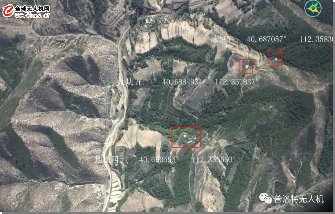
(Plot PLT-02 drone in the poppy cultivation area of ​​Liangcheng, Hebei Province)
3. Application of remote sensing of UAVs in new rural planning and construction.
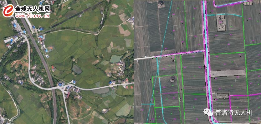
(Plot PLT-30 completes the task of arable land determination in Jixian County, Sichuan Province)
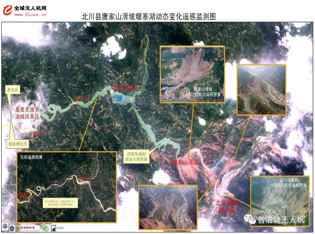
4. Application of remote sensing of unmanned aerial vehicles in emergency handling.

(Plot PLT-40 participates in Wenchuan earthquake disaster monitoring, this is the first time that China has used drones for emergency rescue.)
UAVs provide new ways for people to respond to emergencies (such as traffic fires, large oil pipeline fires, forest fires, nuclear power plant hazards, etc.) with their high maneuverability. The drone can use the shortest time to get close to the disaster scene to the maximum extent, monitor the development of the danger, and transmit the image information of the disaster in real time to provide timely and accurate data for disaster management. It can not only reduce the work risk of disaster relief personnel, but also provide the most direct and true first-hand data to provide a basis for developing effective operational plans.
Technical short board
1. The requirements for landing and landing of large aircraft teams are too high, and the wind resistance of small aircraft is poor.
Larger drones that require slipping and tobogganing are too demanding for landing and landing sites, and bare landings that do not meet the conditions of take-off and landing may damage the aircraft. However, if a small light drone is used, it is susceptible to low wind speed and wind direction. How to make good use of the ejection take-off and collision net recycling technology to reduce the requirements of the drone on the take-off site, and improve the stability of the flight by improving the design and improving the flight control technology without increasing the weight. This is an urgent problem to be solved before the drone becomes an ideal remote sensing platform.
2. Sensor and attitude control technology.
The load of the drone is very limited, and the traditional sensor is often difficult to complete the high-precision aerial photography task in terms of volume and weight. How to make the acquired real-time remote sensing data reach the preset data of the control system at the aerial photography point and the photography scale The parameters such as the degree of overlap and the values ​​of the flight altitude and flight speed are completely consistent. At present, it is necessary to overcome many difficulties.
3. Post-processing techniques for remote sensing data.
Traditional aerial photographs have problems such as small image size and large number of images. They should be developed according to the characteristics of remote sensing images, camera calibration parameters, attitude data during shooting, geometric and radiation correction of images, and corresponding software development. Processing. At the same time, automatic image recognition and rapid splicing software should be developed to achieve rapid inspection of image quality, flight quality and rapid processing of data to meet the real-time and fast technical requirements of the complete UAV remote sensing system.
UAVs will be widely used as a new type of remote sensing platform. A general direction of remote sensing development is high spatial resolution, high spectral resolution, and high temporal resolution. With the increase of the level of multi-spectral sensors, the weight and volume are reduced, UAV remote sensing can not be compared with other remote sensing technologies in many fields such as emergency and disaster monitoring, pests and diseases, alien invasive biological monitoring, and high-time resource monitoring. The advantages.
Car cable harness, also known as a wire harness, cable assembly, wiring assembly or wiring loom, is an assembly of electrical cables or wires which transmit signals or electrical power. The cables are bound together by connector, terminal, cable ties, sleeves, electrical tape, conduit, PVC tube, corrugate tube, string, or a combination thereof.
Commonly used in automobiles, as well as construction machinery, cable harnesses provide several advantages over loose wires and cables. For example, many aircraft, automobiles and spacecraft contain many masses of wires which would stretch over several kilometres if fully extended. By binding the many wires and cables into a cable harness, the wires and cables can be better secured against the adverse effects of vibrations, abrasions, and moisture.
Car Wire Harness,Wiring Harness,Car Electrical Wiring Harness,American Autowire Mustang Harness
Dongguan YAC Electric Co,. LTD. , https://www.yacentercn.com